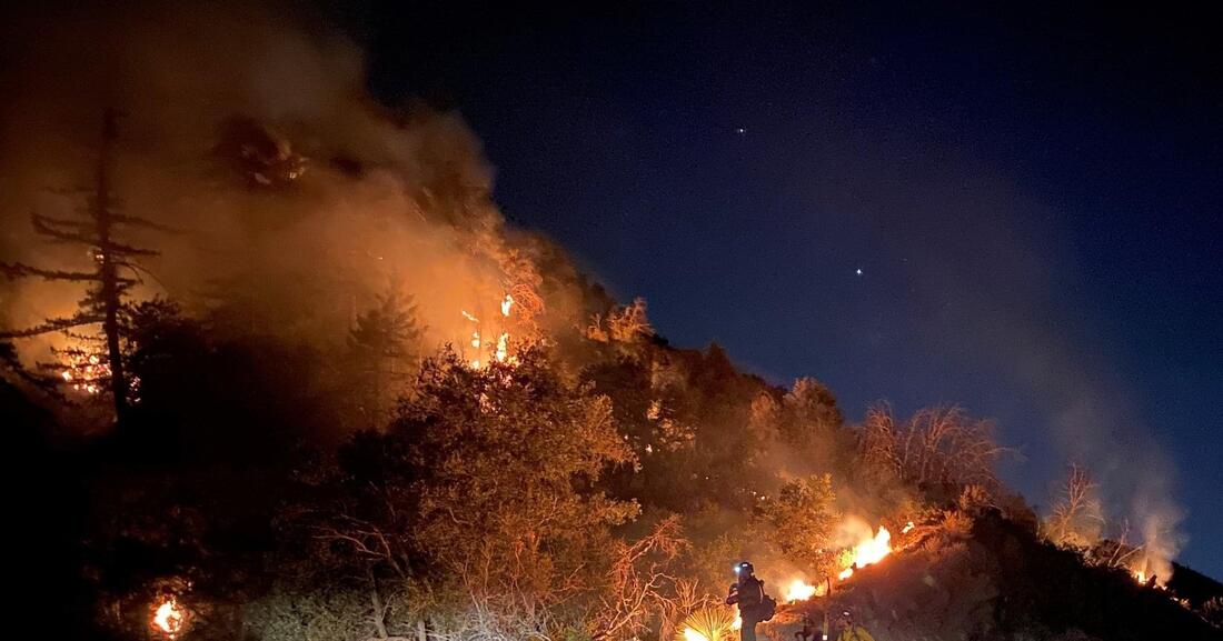
 PHOTO courtesy of the U.S. Forest Service. Written by AARON CASTREJON CityWatch Editor REGION - Authorities have lifted many of the evacuation orders in the Los Angeles and Antelope valleys over the past several days as cooler temperatures have helped firefighters make serious gains on the gargantuan Bobcat Fire. The Bobcat Fire was downgraded to 62 percent contained and has burned 114,200 acres since igniting September 6. Santa Ana winds are forecasted for Monday, bringing warmer and drier conditions to the area and increasing the risk for increased fire activity, according to the Bobcat Fire Unified Incident Command Team. A Red Flag Warning is scheduled from 5 a.m. to 5 p.m. September 28. Authorities began initiating repopulation of some affected areas September 24 in Little Rock, Pearblossom, Juniper Hills, Valyermo, Llano, Big Rock Springs and Largo Vista.
Remaining under evacuation orders are Paradise Springs south of Big Pines Highway, east of Devil’s Punchbowl, west of Largo Vista Road, and north of the forest; south and west of Upper Big Tujunga Canyon, east of Angeles Forest Highway and north of Angeles Crest Highway; Residences along Angeles Crest Highway, between Angeles Forest Highway and Highway 39. Remaining under evacuation warnings are areas south of Big Pines Highway, east of Largo Vista Road, west of 263rd Street E (County line), and north of the forest; south of Mount Emma Road, north of Upper Big Tujunga Canyon, east of Angeles Forest Highway, and west of Pacifico Mountain; East Fork Areas of Julius Klein Conservation Camp 19, Camp Williams, the River Community and unincorporated Wrightwood. For a current list of affected areas, visit the Los Angeles County website for up to date changes.  Written by AARON CASTREJON CityWatch Editor LOS ANGELES - A man accused of driving a truck through a protest in Pasadena May 31 was found with an illegally-obtained weapon, part of a cache of weapons believed to be amassed for acts of civil disorder.
Benjamin Jong Ren Hung, 28, was charged with one count of conspiracy to transport firearms across state lines and to make a false statement in acquisition of firearms. Prosecutors allege Hung, a San Marino resident, acquired a cache of four weapons purchased in Oregon and then transported across the state line into California, according to an affidavit filed with the complaint against Hung. A friend of Hung purchased one handgun in Oregon and allegedly falsely stated that he was the transferee of the weapon, rather than Hung. The weapon was transported to California and kept in Hung’s home prior to the May 31 protest, the affidavit stated. In March, Hung allegedly purchased three additional handguns himself in Oregon and transported them to California. “[Hung] also allegedly amassed other firearms and tactical equipment from suppliers throughout the United States and used his family’s vineyard in Lodi, California as a training camp to prepare to engage in civil disorders,” the affidavit stated. Hung was arrested after attempting to drive through protestors on a street in Old Town Pasadena May 31. Protesters scattered as a truck approached. No one was injured. Pasadena Police searched Hung’s truck and found a loaded semiautomatic handgun, multiple high-capacity magazines loaded with ammunition, an 18-inch machete, $3,200 in cash, a long metal pipe and a megaphone,” the affidavit stated. If convicted as charged, Hung could face a statutory maximum of five years in federal prison, authorities said. This incident was investigated by the FBI’s Los Angeles Joint Terrorism Task Force and Civil Rights squads and the Pasadena Police Department. Hung was ordered detained at an initial appearance in U.S. District Court in Los Angeles Wednesday. He is scheduled for bail status hearing September 28. He is scheduled to be arraigned October 15. Evacuation Warnings Lifted for Some SGV Communities as Bobcat Fire Tears Through Antelope Valley9/21/2020 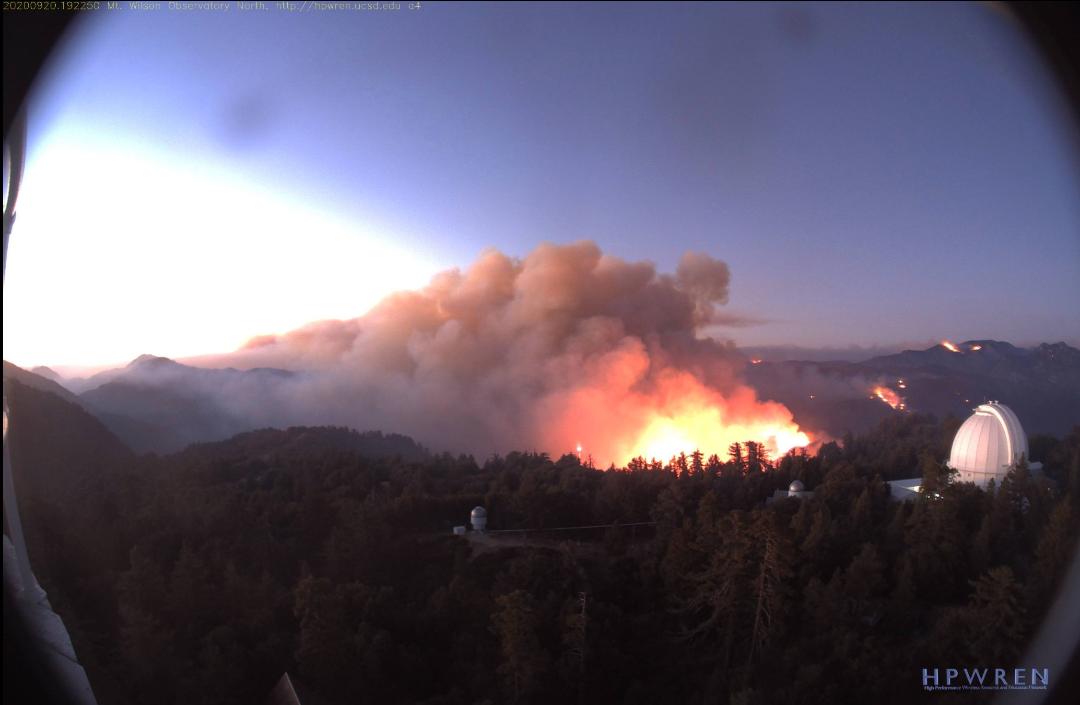 PHOTO courtesy of the Mt. Wilson Observatory. Evacuation Warnings Lifted for Some SGV Communities as Bobcat Fire Tears Through Antelope Valley9/21/2020 PHOTO courtesy of the Mt. Wilson Observatory. Written by AARON CASTREJON CityWatch Editor REGION - The looming threat of destruction from the Bobcat Fire is largely gone for Duarte, Bradbury, Monrovia, Arcadia and Sierra Madre after authorities lifted evacuation warnings over the weekend. The evacuation warnings were lifted at 4 p.m. September 19. The Bobcat Fire has scorched 105,345 acres and is 15 percent contained, according to the Bobcat Fire Unified Incident Command Team. Evacuation warnings remain in effect for Pasadena and Altadena. More than 50 square miles have burned across the San Gabriel Mountains and has made headway into the Antelope Valley where homes and other structures have been turned to ash and rubble. The fire continues to threaten and has destroyed homes in the communities of Juniper Hills, Paradise Springs, Devil’s Punchbowl where evacuation orders remain, according to the Bobcat Fire Unified Incident Command Team. Unfortunately, homes did burn in the Antelope Valley area.
Communities near the burn area under evacuation warnings include Pasadena, Altadena and Wrightwood. For a complete list, click this link. Firefighters continued to hold special emphasis on strengthening fire lines around the Mount Wilson observatory, which is still standing even as the bobcat fire continues to move westward. Southerly winds, sometimes gusting to 20 miles per hour up canyon and 30 miles per hour at the ridges, helped to drive intense fire activity in the San Gabriel Mountains wilderness area. Wind intensity is expected to remain unchanged today. An evacuation center for residents is located at Palmdale high school, 2317 East Ave. R. The Antelope Valley fairgrounds, 2551 W. Avenue H in Lancaster, are open to accommodate large animals.  Written by AARON CASTREJON CityWatch Editor REGION – The man police accuse of setting the Ranch 2 Fire appeared in court September 11. Osmin Palencia, 36, pleaded not guilty to one felony count each of arson during a state of emergency and arson of a structure or forest, according to the Los Angeles County District Attorney’s Office. Police accuse Palencia of intentionally starting a fire that grew to burn 4,237 acres. The blaze, dubbed the Ranch 2 Fire, was reported to authorities around 2:53 p.m. August 13. Azusa Police allege Palencia ignited the fire during an argument. He is apparently a homeless man who lives in a tent near where the fire started at San Gabriel Canyon Road and Ranch Road.
The case against Palencia also includes allegations that he was previously convicted of dissuading a witness in 2015, according to Ricardo Santiago of the Los Angeles County District Attorney’s Office. Palencia faces a possible maximum of 23 years in state prison if convicted as charged. Palencia is scheduled to return to court December 9. 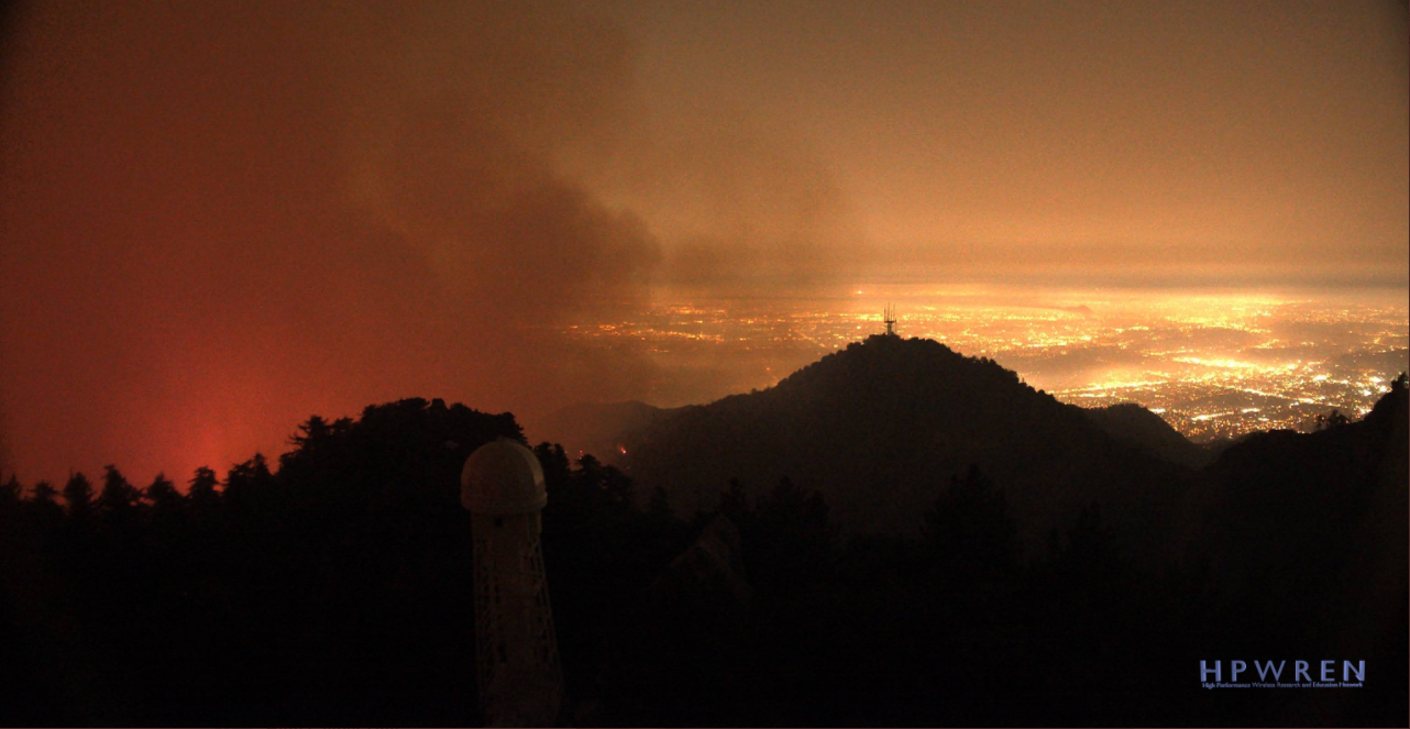 PHOTO from the Mt. Wilson Observatory. Written by AARON CASTREJON CityWatch Editor REGION - The Bobcat Fire continues to churn its way through the San Gabriel Mountains and has burned 44,393 acres, authorities said Tuesday night. As the fire continues to burn westward towards Mount Wilson and northbound across Angeles Crest Highway, activity on the eastern flank has lessened to the point where mountain residents and workers east of San Gabriel Canyon Road have been allowed back. Fire activity near San Gabriel Canyon Road has diminished to the point where authorities gave residents of the Camp Williams area the opportunity to return home. The burn scar created by the Ranch 2 Fire is helping to keep flames west of the road. The occupants of River Community Rehab and Camp 19 along East Fork Road have also returned, according to the U.S. Forest Service. The fire remains 3 percent contained. The infrastructure at the Mount Wilson observatory property remains standing after very diligent work by firefighters who strategically burned away problematic vegetation in the nearby area. Established fire lines created by bulldozers were complemented by fire fighting operations from the air, the U.S. Forest Service said.
The already established defensible space around the Mount Wilson Observatory also greatly helped in keeping flames away from the historical site. Simultaneously, firefighters continued their diligent work on maintaining fire lines on the southern flank of the fire where homes nestled in the foothills of Arcadia and Monrovia stand. Residents of Monrovia likely saw fire activity near the Sawpit Dam and Spanish Canyon areas Tuesday night as firefighters strategically burn vegetation to strengthen defensible space. Despite firefighters’ efforts, a spot fire jumped north of Angeles Crest Highway and burned 500 to 1000 acres Tuesday. The spot fire was eventually extinguished, according to the U.S. Forest Service. Evacuation orders were issued for residents in the area north of Angeles Crest North and between Clear Creek Station and San Gabriel Canyon Road., the U.S. Forest Service said. Residents and business owners that live in the East Fork area between Highway 39 to the west and Glendora Mountain Road to the east can access their community through Glendora Mountain Road in Glendora, the U.S. Forest Service said. Residents of Arcadia and Sierra Madre neighborhoods north of Elkins Avenue and east of Santa Anita Avenue are still under mandatory evacuations. A Red Cross evacuation center is available at Santa Anita Park, 285 W. Huntington Dr., in Arcadia. Enter through Gate 5. Call 1-800-675-5799 for more information.  Written by AARON CASTREJON CityWatch Editor REGION - Nearly 38,300 acres have burned in the San Gabriel Mountains since the Bobcat Fire ignited eight days ago and containment figures are dwindling closer to zero.
Fire growth has outpaced containment, forcing firefighters to downgrade the long-standing 6 percent containment they fought to maintain and are reporting the fire is now only 3 percent contained, according to the U.S. Forest Service. A main focus for firefighters over Monday night is to strategically set back fires within the Chantry Flats area above Arcadia and Sierra Madre when opportunities permit, the U.S. Forest Service said. Not only are homes in Arcadia and Sierra Madre in harm’s way, but the Mt. Wilson Observatory and nearby radio transmission towers stand to succumb to the insatiable fire. “The fire crossed a dozer line and is burning on the ridge line above the east side of Little Santa Anita Canyon,” according to the U.S. Forest Service. “Fire activity was heavy on the west side near Winter Creek and the Santa Anita Wash with fire progressing 3/4 of the way up to the Mt. Wilson ridge line.” All personnel from the Mount Wilson observatory have evacuated the property. A mandatory evacuation order remains in effect for an unknown duration for the neighborhoods in Arcadia east of Santa Anita Avenue and north of Elkins. About 305 homes were evacuated. 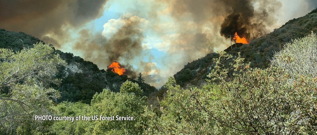 Written by AARON CASTREJON CityWatch Editor REGION - Flames continue to push their way west along the San Gabriel Mountains as the Bobcat Fire burns for a eighth straight day with little containment.
The fire has burned 36,366 acres and is still only 6 percent contained, according to the U.S. Forest Service. The fire jumped over a contingency line and is burning on the ridgeline above the east side Little Santa Anita Canyon, according to Sierra Madre authorities in a written statement. Sierra Madre will be issuing an order in the next hour directing all properties in the canyon to remove any vehicles, personal property, debris, or any other object that is in the public right of way. Any property in the public right of way will be removed or towed beginning at 6:00 p.m. Monday, Sierra Madre authorities said. 305 homes have been evacuated. The evacuation orders for the neighborhoods East of Santa Anita Avenue and Elkins remains in effect until further notice. The fire remains active in an area west of Santa Anita Canyon and the Santa Anita Dam. Despite work building a containment line with bulldozers, hand crews and fire retardant, the Bobcat Fire jumped a contingency line north of Santa Anita Canyon, according to Sierra Madre authorities. Firefighters were anxious of the fire’s potential encroachment on homes as it made slow runs on the northern side of Clamshell Trail, Monrovia authorities said. The fire failed to make a run for a ridge line and put itself dangerously close to homes above Cloverleaf Drive. “The fire never made the run that we thought it could and was never closer than a mile to Hidden Valley Road,” Monrovia authorities said in a written statement. There are 888 personnel assigned to the Bobcat Fire, along with 78 engines, 17 hand crews, five helicopters, four fixed-wing aircraft, eight bulldozers and five water tenders, according to Duarte authorities. 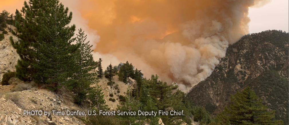 Written by AARON CASTREJON CityWatch Editor REGION – The stubborn Bobcat Fire tearing its way through the San Gabriel Mountains is 6 percent contained Friday, the U.S. Forest Service said. 26,368 acres have burned in the steep, rugged mountain terrain since the fire’s inception five days ago. 540 firefighters from surrounding agencies, assisted by helicopters and some fixed-wing aircraft, continue to focus work on the south and north flanks of the fire that continue to grow. Firefighters achieved containment on the eastern flank where the Bobcat Fire ran into the burn scar etched by the Ranch 2 Fire, the U.S. Forest Service said. Two air tankers were able to perform drops of fire retardant Thursday after dense smoke on the south flank above Monrovia lifted. A helicopter and two groups of camp crews were also sent to bolster fire lines there, the U.S. Forest Service said. Overnight, two Los Angeles County Fire Department helicopters equipped with night vision were able to tend to flames on the south flank.
Winds continue to push the fire north towards Crystal Lake. Flames have reached the into the upper ridges near Angeles Crest Highway where fire retardant line have been laid by aircraft, the U.S. Forest Service said. Ground crews will continue to patrol the foothill communities and conduct structure protection and triage efforts, the U.S. Forest Service said. The City of Monrovia has established road blocks along planned evacuation routes and bolstered the areas with additional police patrols to push non-residents and unnecessary traffic out of the area, Monrovia city officials said. Unnecessary vehicle traffic created what Monrovia officials considered public safety concerns and apparently even delayed fire trucks from being able to move from location to location, Monrovia city officials said. Firefighters estimate the Bobcat Fire may be contained by October 15. Zero Containment: Bobcat Fire Chars Nearly 24,000 Acres, Burns Deeper Towards Crystal Lake9/10/2020 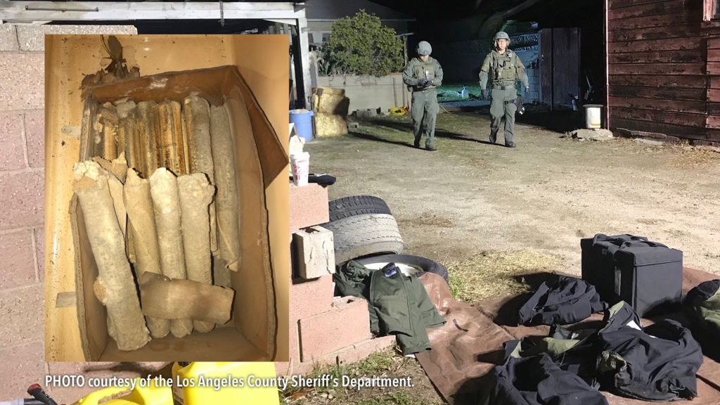 Written by AARON CASTREJON CityWatch Editor REGION - Weather conditions and poor visibility are keeping firefighters from gaining an upper hand on the Bobcat Fire.
23,890 acres have burned in the parched and steep terrain of the San Gabriel Mountains since the fire’s inception four days ago. Firefighters have 0 percent containment, according to the U.S. Forest Service. More than 530 firefighters continue to work on keeping the fire from spreading further south. On the bright side, voluntary evacuation orders for Sierra Madre and Arcadia were lifted Thursday. However, Arcadia residents north of Foothill Boulevard and East of Pasadena remain under evacuation warnings. Evacuation warnings remain in effect for Pasadena, Monrovia, Duarte, Bradbury and Duarte Mesa. The Angeles National Forest remains closed for recreation. Overnight, the Bobcat Fire jumped San Gabriel Canyon Road as it burned heavily northeast. Angeles Crest Highway (State Route 2) is closed eastbound from Upper Big Tujunga Canyon Road to Big Pines. San Gabriel Canyon Road (Highway 39) is closed at Old San Gabriel Canyon Road, according to Caltrans. The fire has cast a morbid orange haze over the Southland as the smoke mixes with cloud cover. An unending drizzle of ash and dirt from the burn site continues to sprinkle over the urban landscape. Burning up is mostly old-growth chaparral and tall grass in areas with little to no fire record. Firefighters have no estimate on containing the fire. |
Archives
January 2024
Categories
All
|
 RSS Feed