 Written by AARON CASTREJON CityWatch Editor REGION - The National Weather Service has issued a flood advisory effective until 8:45 p.m. Sunday.
Flooding caused by excessive rainfall May likely affect the foothills of the San Gabriel Valley into the eastern mountains of the San Gabriel Valley, according to the NWS. “Heavy rainfall could trigger shallow debris flows in and near the Bobcat, Ranch, and Fish burn scars. Roadway flooding is expected including Highway 210, as well as rises in small streams and normally dry arroyos is expected,” the NWS said in a written statement. A flash flood warning is also in effect for northwestern Los Angeles County until 9:15 p.m. 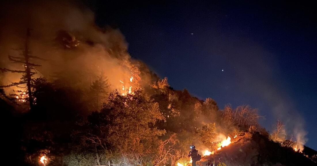 PHOTO courtesy of the U.S. Forest Service. Written by AARON CASTREJON CityWatch Editor REGION - Authorities have lifted many of the evacuation orders in the Los Angeles and Antelope valleys over the past several days as cooler temperatures have helped firefighters make serious gains on the gargantuan Bobcat Fire. The Bobcat Fire was downgraded to 62 percent contained and has burned 114,200 acres since igniting September 6. Santa Ana winds are forecasted for Monday, bringing warmer and drier conditions to the area and increasing the risk for increased fire activity, according to the Bobcat Fire Unified Incident Command Team. A Red Flag Warning is scheduled from 5 a.m. to 5 p.m. September 28. Authorities began initiating repopulation of some affected areas September 24 in Little Rock, Pearblossom, Juniper Hills, Valyermo, Llano, Big Rock Springs and Largo Vista.
Remaining under evacuation orders are Paradise Springs south of Big Pines Highway, east of Devil’s Punchbowl, west of Largo Vista Road, and north of the forest; south and west of Upper Big Tujunga Canyon, east of Angeles Forest Highway and north of Angeles Crest Highway; Residences along Angeles Crest Highway, between Angeles Forest Highway and Highway 39. Remaining under evacuation warnings are areas south of Big Pines Highway, east of Largo Vista Road, west of 263rd Street E (County line), and north of the forest; south of Mount Emma Road, north of Upper Big Tujunga Canyon, east of Angeles Forest Highway, and west of Pacifico Mountain; East Fork Areas of Julius Klein Conservation Camp 19, Camp Williams, the River Community and unincorporated Wrightwood. For a current list of affected areas, visit the Los Angeles County website for up to date changes. Zero Containment: Bobcat Fire Chars Nearly 24,000 Acres, Burns Deeper Towards Crystal Lake9/10/2020  Written by AARON CASTREJON CityWatch Editor REGION - Weather conditions and poor visibility are keeping firefighters from gaining an upper hand on the Bobcat Fire.
23,890 acres have burned in the parched and steep terrain of the San Gabriel Mountains since the fire’s inception four days ago. Firefighters have 0 percent containment, according to the U.S. Forest Service. More than 530 firefighters continue to work on keeping the fire from spreading further south. On the bright side, voluntary evacuation orders for Sierra Madre and Arcadia were lifted Thursday. However, Arcadia residents north of Foothill Boulevard and East of Pasadena remain under evacuation warnings. Evacuation warnings remain in effect for Pasadena, Monrovia, Duarte, Bradbury and Duarte Mesa. The Angeles National Forest remains closed for recreation. Overnight, the Bobcat Fire jumped San Gabriel Canyon Road as it burned heavily northeast. Angeles Crest Highway (State Route 2) is closed eastbound from Upper Big Tujunga Canyon Road to Big Pines. San Gabriel Canyon Road (Highway 39) is closed at Old San Gabriel Canyon Road, according to Caltrans. The fire has cast a morbid orange haze over the Southland as the smoke mixes with cloud cover. An unending drizzle of ash and dirt from the burn site continues to sprinkle over the urban landscape. Burning up is mostly old-growth chaparral and tall grass in areas with little to no fire record. Firefighters have no estimate on containing the fire.  Written by AARON CASTREJON CityWatch Editor REGION - A source of a strange scent wafting over several San Gabriel Valley cities was not located by firefighters Thursday.
Residents reported the chemical smell in Azusa, Glendora, Covina and San Dimas. Dispatch Supervisor Imogene McBride of the Los Angeles County Fire Department said firefighters were dispatched to two different locations after calls from residents. Firefighters were dispatched to the 600 block of Enid Avenue in Covina at 3:39 p.m. to determine a source of the stink. Firefighters were soon dispatched to East Claraday Street and South Bradford Drive at 3:45 p.m. in Glendora on a second report. There were no structure or vehicle fire reports in the area of that time. A source was not located. |
Archives
January 2024
Categories
All
|
 RSS Feed